
Sydney temperatures plummeted by up to 15 degrees in an hour on Tuesday afternoon on a day of extremes when the mercury peaked at 43 degrees.
Much of NSW had temperatures in the high 30s or low 40s, with Sydney sweltering through its hottest day of the year.
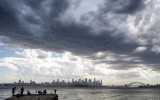
But a southerly buster swept through the capital late Tuesday, bringing rain, hail and 83km/h winds that swept away the heatwave.
Sydney Olympic Park fell from 41 to 29 degrees in less than an hour.
“In around two hours, temperatures have dropped around 10 to 15 degrees around the place,” meteorologist Edward Townsend-Medlock said.
Sydney Airport reached a high of 43 degrees while Penrith, Bankstown and Badgerys Creek also topped 40 degrees.
Temperatures were in the high 30s for much of the Illawarra region with Nowra and Kiama reaching 39 degrees.
Townsend-Medlock said the heat in the coastal areas was not as high as predicted due to an earlier-than-expected afternoon storm.
“The lovely change that came through today came a little bit earlier than expected, stopping coastal areas from reaching their maximum forecast of 40 degrees,” he said.
Meanwhile, the weather bureau of monitoring a seven-day cyclone risk to Queensland from the Indian Ocean to the Gulf of Carpentaria and into the Coral Sea.
The bureau said a tropical low in the Coral Sea had a 25-30 per cent chance of forming into a cyclone over the weekend and into next week.
“It is likely, depending on where it moves to and forms, it may increase rainfall over parts of far northern Queensland, particularly if it moves close to the coastline,” Townsend-Medlock said.
Large parts of Queensland, including the north-west, central-west and channel country, reached temperatures in the low-mid 40s on Tuesday.
Some towns in Western Australia’s Pilbara, Gascoyne and north interior regions reached 46 degrees on Tuesday.
The Northern Territory interior also had a sweaty Tuesday, including in Alice Springs where temperatures soared to 43 degrees.
-with AAP
Live News