
Parts of Sydney have been smashed by wild thunderstorms, which brought heavy rain, flash flooding and hail.
The storm hit on Monday afternoon, after a warning from the weather bureau.
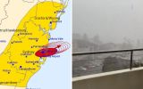
“The Bureau of Meteorology warns that, at 3.10pm, a severe thunderstorm likely to produce heavy rainfall that may lead to flash flooding was detected near Sydney City, Sydney Olympic Park, the Sydney Harbour Bridge and waters off Bondi Beach,” it wrote.
“This thunderstorm is moving towards the north-east. It is forecast to affect Manly, St Leonards and waters off Manly Beach by 3.40pm and Chatswood, Dee Why and waters off Dee Why Beach by 4.10pm.”
There were also warnings for other areas for later on Monday, including Gosford, Sydney, Penrith, Parramatta, Campbelltown and Taralga.
“Hail in Forestville. Local flooding in the area. Roseville bridge has flooding,” wrote one X user on Monday afternoon.
“Came through Campbelltown at 2.30 just before school pick-up, like usual,” wrote a Facebook user.
By 3.30pm (AEDT), there were reports of more than 23 millimetres of rain at Canterbury, and a further 15 millimetres in the Sydney CBD.
Storms are firing up across parts of NSW.
Just a reminder that if you require storm assistance call the NSW SES on 132 500 and Triple Zero for life threatening emergency.
🎥 storm moves across Picton in the Southern Highlands a short time ago. pic.twitter.com/V15ESYFVrU— NSW RFS (@NSWRFS) October 14, 2024
Sydney Airport confirmed there had been flight delays due to the wild weather.
“Due to storm activity, there have been some flight delays,“ a Sydney Airport spokesperson said.
“We encourage passengers to check with their airline regarding the status of their flight.”
Light rail services in Sydney were also affected by flooding.
It came as a week of unsettled weather loomed across Australia.
Forecaster Weatherzone said there would be thunderstorms every day “as a series of troughs and low-pressure systems pass over the country, with a particularly nasty outbreak of severe storms set to erupt between Wednesday and Friday”.
“Thunderstorms were already occurring over parts of southern and eastern Australia on Monday morning. Showers and storms will become more active over the country’s east on Monday afternoon and severe storms could develop over parts of central and southern NSW in the afternoon or evening,” Weatherzone wrote early on Monday.
NSW SES advises residents in Gosford, Sydney, Penrith, Parramatta, Campbelltown & Taralga to MONITOR CONDITIONS for forecast HEAVY RAIN. Avoid unnecessary travel, secure outdoor items, and have your emergency kit ready. Full warning: https://t.co/BwaeYvwV74 pic.twitter.com/BqWvKkH0Fa
— NSW SES (@NSWSES) October 14, 2024
Storms are also expected over a broad area of Australia – including parts of NSW, Victoria, South Australia, Queensland and possibly Tasmania – on Tuesday and Wednesday.
Western Australia will get in on the action on Wednesday, with storms building in its south as a cold front and low-pressure system hit the state.
“Some of these storms are likely to become severe, with damaging to destructive winds, large hail and heavy rain all a risk,” Weatherzone said.
Live News