
Damaging winds, rain and hazardous surf are closing in on millions of Australians, as an east coast low develops off NSW.
The deepening coastal trough over south-east Queensland and north-east NSW had already brought widespread rainfalls of up to 70 millimetres late on Sunday and into Monday, forecaster Weatherzone said.
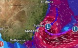
But it is the coming days that have caused the most alarm, with the coastal trough positioned off NSW’s northern rivers forecast to rapidly intensify through a process known as explosive cyclogenesis.
“This explosive process means that the central pressure of the system is expected to drop rapidly,” Weatherzone said.
“The [rapid drop] classifies the system as a bombing low.”
Widespread rain, with isolated falls up to 200 millimetres, and waves of up to seven metres are expected from Forster on the NSW mid-north coast to Batemans Bay on the South Coast.
The NSW SES has already deployed high-clearance vehicles to Kiama, Albury, Hawkesbury, Maitland, Dungog and Taree, with aerial assets located Albion Park, Taree and Cessnock.
Hundreds of volunteers are on standby across a wide area from Sydney’s northern suburbs to the south coast. SES Deputy Commissioner of Operations Debbie Platz said all those in the warning zone should have evacuation plans.
“We need you to prepare so that you don’t need us to respond to you,” she said on Monday.
“Please have an evacuation plan ready, have your emergency kits ready and please make sure you communicate with family friends and check on your neighbours and keep every safe.”
Bureau of Meteorology hazards manager Steven Bernasconi said the coastal low was forecast to develop off the NSW north coast on Monday night
“It’s looking like it will bring damaging winds, heavy rain and hazardous coastal conditions from Tuesday through to Wednesday,” he said.
“The most intense conditions [are] likely to be Tuesday afternoon into Wednesday. Widespread rainfall totals of 50 millimetres to 120 millimetres are likely, but there is still a chance of isolated 150-200 millimetres.”
Bernasconi said the heaviest falls were likely from the Hunter to Illawarra on Tuesday and Wednesday – regions still recovering from record floods in May that claimed the lives of three people and damaged hundreds of properties.
Dairy farmer Michael Jeffery, whose sodden farm lies on the banks of the Macleay River, near Kempsey, said the rain had reignited the catastrophic flood event in people’s minds.
“It’s been raining all day already and that’s really got everybody on edge,” he said on Monday.
“It causes a lot of concern, because your livelihood is at risk, all the infrastructure on your farm that’s already been damaged by a flood and you worry about all your cattle and their wellbeing.”
Jeffery, who is the chairman of dairy co-operative Norco, said the May floods had cost him more than $1 million, prompting him to sell more than 100 milking cows.
From Queensland to Victoria
A flood watch was current on Monday afternoon for the southern parts of the mid-north coast, the Hunter, the Hawkesbury, Sydney, the Illawarra coast and also the Snowy River catchment.
Winds with gusts up to 100km/h are also expected between Batemans Bay and Port Macquarie on Wednesday morning.
The system could potentially spread into southern Queensland and as far south as eastern Victoria, including areas around Gippsland.
“The position, though, and the strength of the low will determine the duration and the severity of the impacts, which may persist into Thursday,” Bernasconi said.
Weatherzone said the east coast low was expected to move into the Tasman Sea on Thursday afternoon, with heavy rain and strong winds gradually easing as it did.
“By late on Thursday, or early on Friday, most of the rain should be offshore, with winds abating as well. The swell is expected to remain large into Friday, but should ease significantly into the weekend,” it said.
-with AAP
Live News